Wheaton Ecogeomorphology & Topographic Analysis Lab @ Fluvial Habitats Center
  • Home
    • Fluvial Habitats Center
    • Wheaton et al (Lab)
    • Bouwes ELR Lab
    • News & Annoucements
    • New FHC Publications
    • FHC Location
    • FHC Factsheets & Posters
    • Contact
  • People
    • People in the Lab... Coming & Going
    • Graduate Students >
      • Lauren Herbine
      • Karen Bartelt
    • Research Staff >
      • Research Scientists >
        • Joe Wheaton
        • Nicolaas Bouwes
        • Wally Macfarlane
        • Stephen Bennett
      • Technicians >
        • Cashe Rasmussen
        • Chalese Hafen
        • Dylan Baum >
          • Brian Ferrara
    • Where are they now? >
      • Former Graduate Students >
        • Sara Bangen
        • Reid Camp
        • Florence Consolati
        • Daniel Hamill
        • Konrad Hafen
        • James Hensleigh
        • Nate Hough-Snee
        • Alan Kasprak
        • Martha Jensen
        • Ryan Lokteff
        • Connor Penrod
        • Rebecca Rossi
        • Sonya Welsh
      • Research Scientists >
        • Sara Bangen
        • James Hensleigh
        • Natalie Kramer
        • Pete McHugh
        • Elijah Portugal
        • Carl Saunders
        • Eric Wall
        • Gary O'Brien
      • Post-Docs >
        • Nicole Czarnomski
      • Technicians >
        • Micael Albonico
        • Braden Anderson
        • Adan Banda
        • Jordan Burningham
        • Kenny Demeurichy
        • Taylor Dudunake
        • Martha Jensen
        • Joshua Gilbert
        • Jordan Gilbert
        • Thomas Hafen
        • Landon Haycock
        • Matt Meier
        • Chris Smith
        • Geoff Stevens
      • Visiting Scholars >
        • Ester Ramos
  • FHC Projects
    • Current Projects >
      • Beaver Dam Censusing
      • Birch Creek Restoration
      • Escalante Watershed
      • BRAT 2018-2019 >
        • BRAT-Yakama
        • BRAT-John Day
        • BRAT-NF Burnt River
        • BRAT-Idaho
        • BRAT-Utah
        • BRAT-TNC
        • BRAT-GYA
        • Survey123
      • ELR: Asotin LWD Restoration and IMW
      • Price River Channel Analysis
    • Past Projects >
      • BLM >
        • BLM: Historic Sand Cliff Signatures Public Archeology Program
      • DOE: ICRRR >
        • DOE/ICRRR: Geomorphic Change Detection 4.0 Software Development
        • DOE/ICRRR: Geomorphic Change Detection in the Grand Canyon
        • DOE/ICRRR: MoRPHED PhD Studentship
      • Idaho Power Company >
        • Idaho Power: TLS Data Analysis
      • ELR >
        • ELR/BPA: CHaMP Grand Ronde Crew Variability Study
        • ELR/BPA: ISEMP Lemhi Topographic Survey Technique Intercomparison
        • ELR/BPA: ISEMP Bridge Creek Restoration & IMW
        • ELR/FHC/CTWS: Pine Creek Beaver Assisted Restoration Pilot Project
      • NSF >
        • NSF: zCloudTools: Making Point Clouds Useful for Earth Science
        • NSF: Sensitivity of Braided River Morphodynamics to Sediment Supply
      • UDWR >
        • UDWR: Beaver Restoration Assessment Tool (BRAT)
      • USFS >
        • USFS Classification of Columbia River Basin Riparian Vegetation
        • USFS: Comparison of Traditional Versus Ground-Based LiDaR Instream Haibtat Assessments
        • USFS: Temple Fork Watershed Fish & Beaver Ecology
      • USGS >
        • USGS: Big Rivers Monitoring Protocol Development
        • USGS: Dynamism and Persistence of Eddy Sand Bars in Grand Canyon
        • USGS: Riparian Vegetation Analysis
        • USGS: Support in Geographic and Geomorphic Information Analysis for the Colorado River in Grand Canyon
      • Other Sponsors (one off) >
        • BPA/SFR: Development of CHaMP Transformation Tool
        • GCT: Pilot Study: Testing the Beaver Restoration Assessment Tool (BRAT)
        • NOAA: Linking Fisheries,
        • NPS: Assessment of Indicator Sites
        • USU: Tracking Ecogeomorphic Dynamics in Beaver Dam Complexes
    • Study Site Pages >
      • Bridge Creek >
        • 2009 BDSS Structures
        • Bridge Creek April 2010 Drone Survey
      • River Feshie >
        • The River Feshie Catchment
        • Our Research
        • The Team
        • Posters, Papers, & More
        • Photo Gallery
  • Resources
    • ETAL Reading Group >
      • ETAL Reading Group Zotero Library
    • Courses & Workshops >
      • Courses & Workshops by Joe
    • Guides & Tips >
      • Figure Preparation Tutorials
      • Basic Computing Tips & Tricks >
        • Database & SQL Intro
        • Batch Unzip Script
        • Get a QR Code
        • GeoJSON
        • Markdown
        • Special Characters
        • USU VPN
      • GIS Help >
        • ArcGIS Education Edition
        • GIS Data Sources >
          • Connecting To The APFO Services
          • Connecting to the Utah AGRC Discover Imagery and Base Map Server
          • High Resolution Imagery for Utah State
      • How to Use Specific Software >
        • Adobe Illustrator >
          • Making GCD Figures for ET-AL Lab Using ArcGIS & Adobe Illustrator
        • ArcGIS Desktop - ArcMap >
          • GIS Tutorials
          • Creating DEMs, TINs and Terrains
          • How to divide polylines into a specified segment length
          • Simple Change Detection in ArcGIS
          • Working with Styles in ArcGIS
          • Fixing ActiveX Warning in ArcGIS 10.5
        • Box >
          • Migrating to Box Drive from Box Sync
        • EndNote >
          • EndNote X4 Basics
        • FastStone Capture
        • GitHub >
          • Make a GitHub Account
        • Picasa >
          • Geotagging images & making albums
        • Word >
          • Saving Word Documents as PDFs
          • Using Styles Effectively in Manuscripts & Reports
        • Zotero >
          • Adding from Browser
          • Cite-While-you-Write >
            • Citing in Google Docs
            • Cite in Word
      • Reccomended Software & Utilities
      • Surveying & Geomatics >
        • rtkGPS
      • Writing Resources >
        • Writing Literature Reviews (for Grads)
        • Writing Scientific Papers
        • Uploading Content to Research Gate
    • Lab Members Only >
      • Internal Resources >
        • When you First Start
        • Standard Software Suite
        • Lab Software License
        • Virtual Computing
        • Editing Workshop Flyers & Webpages
        • Travel
        • Vignettes
      • Internal FHC Announcements
      • FHC Workshops
      • ETAL Projects on Box
      • ETAL Non Project on Box
    • River Links >
      • Classification Schemes >
        • Eco-Geo-Hydro Mess
      • Free Literature
      • Rivers in the News
      • Videos & Galleries
  • Joe Wheaton

News

Geomorphic Change Detection workshop

2/17/2018

0 Comments

 
PicturePhoto: Surveying on the Logan River, Rendezvous Park
Government and industry resource managers, restoration practitioners, and researchers attended a recent Geomorphic Change Detection workshop, in Logan, Utah on April 29 – May 1.
Participants learned surveying techniques on the Logan River, as well as theory and tools behind geomorphic change detection from repeat topographic surveying and how to apply the Geomorphic Change Detection software to their own monitoring data. 
The workshop was led by Dr. Joe Wheaton, along with Dr. Philip Bailey, of North Arrow Research, and James Hensleigh, Sara Bangen, and Kenny DeMeurichy, all of USU.
Future workshops are tentatively scheduled to be held in New Zealand, Spain, Lyon, France, and back in Logan, UT in April 2017. See here for more details.


Originally posted Jun 16, 2015, 11:27 AM by Jeannine Huenemann
0 Comments

Kenny DeMeurichy launches surveying blog!

2/17/2018

0 Comments

 
Picture
ET-AL survey lead, and all-around MVP Kenny DeMeurichy has launched a blog to discuss surveying, stream monitoring, and his travels throughout his many USU and FHC projects. Check it out at: 


http://geohydrodynamatics.blogspot.com/


And throughout your field work, remember, when it all hits the fan, don't panic. Keep it cool. Keep it Kenny.
​
Originally posted Jun 11, 2015, 1:43 PM by Nate Hough-Snee
0 Comments

Hough-Snee wins SWS Research Grant

2/17/2018

0 Comments

 
Picture
The ET-AL lab's Nate Hough-Snee recently brought home the bacon, winning a student research grant from the Society of Wetland Scientists. Nate will use these funds to support his ongoing research that examines the ability of beaver dams to acts as buffers against erosion in flashy, arid streams.  Most importantly, the grant will support post-restoration geomorphic monitoring to better understand the annual-scale efficacy of beaver-assisted restoration projects. ​

Originally posted May 4, 2015, 10:24 AM by Alan Kasprak
0 Comments

Kasprak wins best student paper award at SEDHYD2015

2/17/2018

0 Comments

 
Picture
The ET-AL's Alan "cash money" Kasprak has taken the top award in the "Best Student Competition" at the interagency conference on sedimentation and hydrologic modeling for his work modeling the evolution of braided rivers. Congrats Alan! 

From yesterday's announcement:
I'm stoked for @CNRUSU's @AlanKasprak, winner of the #SEDHYD2015 best student paper award! #Rivers #Reno#CacheMoney pic.twitter.com/5wwg8IqJHT
— Nate Hough-Snee (@NHoughSnee) April 21, 2015
Originally posted Apr 22, 2015, 4:04 PM by Nate Hough-Snee
0 Comments

Hough-Snee delivers talk at Society of Wetland Scientists Rocky Mountain meeting

2/17/2018

0 Comments

 
Under the glow of the Coors Brewing Company and Colorado School of Mines, Nate delivered the opening talk at the Society of Wetland Scientists' Rocky Mountain meeting in Golden, CO last week. His slides, "Beaver emulation and facilitation to restore streams: cases from the semi-arid West" are now hosted at Figshare (linked above).

Originally posted Apr 19, 2015, 7:22 PM by Nate Hough-Snee 
0 Comments

Elijah featured in UPR Radio 'The Source' on making rivers and streams messier!

2/17/2018

0 Comments

 
Picture
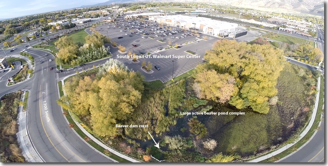
FHC staff, Elijah Portugal was interviewed yesterday by Jennifer Pemberton from Utah Public Radio about the proposed FHC beaver management plan with Walmart and the City of Logan for the Spring Creek Wetland beaver complex.  The radio program is called, 'The Source'  and is a monthly program about water issues in Utah. The story aired Friday April 24th at 9am on 91.5/89.5 FM Logan or upr.org in an hour long segment on 'Rivers & Streams - Messiness Matters'. ​
Originally posted Apr 17, 2015, 12:31 PM by Elijah Portugal ​
0 Comments

Kasprak to Deliver Talk at Grand Canyon Monitoring and Research Center

2/17/2018

0 Comments

 
Picture
This Friday, GCMRC and SBSC are hosting Alan Kasprak who will give a seminar:

"Linking Sediment Transport and Channel Morphology in Braided Rivers"
Brown Bag Seminar
12:00 PM Friday, March 13th
Building 3 Conference Room (#367)


Alan is a PhD Candidate at Utah State University. Please see the abstract for his talk and his biosketch below.


Abstract: Channel form and sediment transport are closely linked in alluvial rivers. This seminar will focus on two research directions, both aimed at developing a better understanding of feedbacks between channel morphology and particle transport specific to braided rivers. The first portion of the seminar will detail a series of laboratory flume experiments that used fluorescent tracer particles coupled with ultra-high-resolution topography and digital elevation model differencing to link particle travel distances with in-channel geomorphic units. The findings underscore the importance of channel bars, particularly bar heads and bar margins, in acting as deposition sites for particles in transport. The second part of the seminar will upscale the results of flume experiments using numerical modeling. By simply modeling the kinematics of sediment transport using path length distributions that predict likely travel distances for particles in transport, we can develop efficient morphodynamic models for braided rivers. The open-source morphodynamic model presented here shows promise both as a validated predictive utility and as an experimental framework for exploring the effect of various process representations on resultant channel form. The results of this research point to fundamental form-process links in braided rivers, where simple relationships between channel morphology and sediment dynamics have long been hypothesized. The understanding gained from these relationships provides a way forward for efficient predictive models of channel evolution at event, annual, and decadal scales.
 
BioSketch: Alan Kasprak is a PhD Candidate in Utah State University’s Watershed Sciences Department, where he works with Dr. Joe Wheaton in the Ecogeomorphology and Topographic Analysis Laboratory. His dissertation focuses on understanding the relationship between sediment transport distances and channel morphology in braided rivers, and using that understanding to develop simple yet predictive morphodynamic models. More broadly, Alan’s research seeks to disentangle natural and anthropogenic drivers of geomorphic change in river systems using high-resolution topographic measurement and analysis techniques. Prior to his time at USU, Alan received a BS in Geology/Geophysics from Boston College, and a Master’s in Earth Sciences from Dartmouth College. 
Originally posted Mar 11, 2015, 10:38 AM by Nate Hough-Snee
0 Comments

Former FHC Grad Blanchard Featured in Survey Magazine

2/17/2018

0 Comments

 
Picture
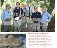
Monica Blanchard, a former Nick Bouwes graduate student and FHC member, is featured in a recent article on salmon monitoring in The American Surveyor, issue February 2015, pages 40-43. Monica serves as Fisheries Biologist at Columbia River Inter-Tribal Fish Commission. Watch for more articles on her project to appear soon.

Originally posted Feb 10, 2015, 4:37 PM by Jeannine Huenemann
0 Comments

Former ET-AL Grad Lokteff becomes Executive Director of GCWIN

2/17/2018

0 Comments

 
Picture
Former ET-AL graduate student Ryan Lokteff just became the new Executive Director for the Grant County Water Information Network in Colorado. Congratulations Ryan! After graduating, Ryan worked for both the USFS and BLM Bug Lab in Logan, Utah. See the article in Sky-Hi News.

Originally posted Jan 10, 2015, 3:40 PM by Joe Wheaton
0 Comments

Losing Paradise: Climate Change is Changing Mount Rainier

2/17/2018

0 Comments

 
​Check out how climate change is affecting glaciers, rivers, floodplains, ecosystems, and public park access at Mount Rainier National Park in a recent article from The News Tribune (Tacoma, WA).
After two field seasons at Mount Rainier National Park, et al. graduate student, Becca Rossi, is featured in the article/video for her research on avulsion channels in the Carbon River Valley (northwest side of the park), and an all park natural hazard inventory and vulnerability assessment. Her contributions have aided in understanding avulsion mechanisms and floodplain response and interaction with large woody debris within an old growth forest. Her efforts have also helped management teams at Mount Rainier evaluate road access and park infrastructure vulnerabilities in the event of future natural hazards. ​
Picture
photo credit: Dean Koepfler
Originally posted Jan 4, 2015, 1:47 PM by Rebecca Rossi
0 Comments
<<Previous
Forward>>

    AuthorS

    Contributions from ETAL lab members.

    Archives

    February 2018

    Categories

    All

    RSS Feed

Picture
Picture
Picture
Picture
Picture
This work is licensed under a
​ 
Creative Commons Attribution 4.0 International License.
  • Home
    • Fluvial Habitats Center
    • Wheaton et al (Lab)
    • Bouwes ELR Lab
    • News & Annoucements
    • New FHC Publications
    • FHC Location
    • FHC Factsheets & Posters
    • Contact
  • People
    • People in the Lab... Coming & Going
    • Graduate Students >
      • Lauren Herbine
      • Karen Bartelt
    • Research Staff >
      • Research Scientists >
        • Joe Wheaton
        • Nicolaas Bouwes
        • Wally Macfarlane
        • Stephen Bennett
      • Technicians >
        • Cashe Rasmussen
        • Chalese Hafen
        • Dylan Baum >
          • Brian Ferrara
    • Where are they now? >
      • Former Graduate Students >
        • Sara Bangen
        • Reid Camp
        • Florence Consolati
        • Daniel Hamill
        • Konrad Hafen
        • James Hensleigh
        • Nate Hough-Snee
        • Alan Kasprak
        • Martha Jensen
        • Ryan Lokteff
        • Connor Penrod
        • Rebecca Rossi
        • Sonya Welsh
      • Research Scientists >
        • Sara Bangen
        • James Hensleigh
        • Natalie Kramer
        • Pete McHugh
        • Elijah Portugal
        • Carl Saunders
        • Eric Wall
        • Gary O'Brien
      • Post-Docs >
        • Nicole Czarnomski
      • Technicians >
        • Micael Albonico
        • Braden Anderson
        • Adan Banda
        • Jordan Burningham
        • Kenny Demeurichy
        • Taylor Dudunake
        • Martha Jensen
        • Joshua Gilbert
        • Jordan Gilbert
        • Thomas Hafen
        • Landon Haycock
        • Matt Meier
        • Chris Smith
        • Geoff Stevens
      • Visiting Scholars >
        • Ester Ramos
  • FHC Projects
    • Current Projects >
      • Beaver Dam Censusing
      • Birch Creek Restoration
      • Escalante Watershed
      • BRAT 2018-2019 >
        • BRAT-Yakama
        • BRAT-John Day
        • BRAT-NF Burnt River
        • BRAT-Idaho
        • BRAT-Utah
        • BRAT-TNC
        • BRAT-GYA
        • Survey123
      • ELR: Asotin LWD Restoration and IMW
      • Price River Channel Analysis
    • Past Projects >
      • BLM >
        • BLM: Historic Sand Cliff Signatures Public Archeology Program
      • DOE: ICRRR >
        • DOE/ICRRR: Geomorphic Change Detection 4.0 Software Development
        • DOE/ICRRR: Geomorphic Change Detection in the Grand Canyon
        • DOE/ICRRR: MoRPHED PhD Studentship
      • Idaho Power Company >
        • Idaho Power: TLS Data Analysis
      • ELR >
        • ELR/BPA: CHaMP Grand Ronde Crew Variability Study
        • ELR/BPA: ISEMP Lemhi Topographic Survey Technique Intercomparison
        • ELR/BPA: ISEMP Bridge Creek Restoration & IMW
        • ELR/FHC/CTWS: Pine Creek Beaver Assisted Restoration Pilot Project
      • NSF >
        • NSF: zCloudTools: Making Point Clouds Useful for Earth Science
        • NSF: Sensitivity of Braided River Morphodynamics to Sediment Supply
      • UDWR >
        • UDWR: Beaver Restoration Assessment Tool (BRAT)
      • USFS >
        • USFS Classification of Columbia River Basin Riparian Vegetation
        • USFS: Comparison of Traditional Versus Ground-Based LiDaR Instream Haibtat Assessments
        • USFS: Temple Fork Watershed Fish & Beaver Ecology
      • USGS >
        • USGS: Big Rivers Monitoring Protocol Development
        • USGS: Dynamism and Persistence of Eddy Sand Bars in Grand Canyon
        • USGS: Riparian Vegetation Analysis
        • USGS: Support in Geographic and Geomorphic Information Analysis for the Colorado River in Grand Canyon
      • Other Sponsors (one off) >
        • BPA/SFR: Development of CHaMP Transformation Tool
        • GCT: Pilot Study: Testing the Beaver Restoration Assessment Tool (BRAT)
        • NOAA: Linking Fisheries,
        • NPS: Assessment of Indicator Sites
        • USU: Tracking Ecogeomorphic Dynamics in Beaver Dam Complexes
    • Study Site Pages >
      • Bridge Creek >
        • 2009 BDSS Structures
        • Bridge Creek April 2010 Drone Survey
      • River Feshie >
        • The River Feshie Catchment
        • Our Research
        • The Team
        • Posters, Papers, & More
        • Photo Gallery
  • Resources
    • ETAL Reading Group >
      • ETAL Reading Group Zotero Library
    • Courses & Workshops >
      • Courses & Workshops by Joe
    • Guides & Tips >
      • Figure Preparation Tutorials
      • Basic Computing Tips & Tricks >
        • Database & SQL Intro
        • Batch Unzip Script
        • Get a QR Code
        • GeoJSON
        • Markdown
        • Special Characters
        • USU VPN
      • GIS Help >
        • ArcGIS Education Edition
        • GIS Data Sources >
          • Connecting To The APFO Services
          • Connecting to the Utah AGRC Discover Imagery and Base Map Server
          • High Resolution Imagery for Utah State
      • How to Use Specific Software >
        • Adobe Illustrator >
          • Making GCD Figures for ET-AL Lab Using ArcGIS & Adobe Illustrator
        • ArcGIS Desktop - ArcMap >
          • GIS Tutorials
          • Creating DEMs, TINs and Terrains
          • How to divide polylines into a specified segment length
          • Simple Change Detection in ArcGIS
          • Working with Styles in ArcGIS
          • Fixing ActiveX Warning in ArcGIS 10.5
        • Box >
          • Migrating to Box Drive from Box Sync
        • EndNote >
          • EndNote X4 Basics
        • FastStone Capture
        • GitHub >
          • Make a GitHub Account
        • Picasa >
          • Geotagging images & making albums
        • Word >
          • Saving Word Documents as PDFs
          • Using Styles Effectively in Manuscripts & Reports
        • Zotero >
          • Adding from Browser
          • Cite-While-you-Write >
            • Citing in Google Docs
            • Cite in Word
      • Reccomended Software & Utilities
      • Surveying & Geomatics >
        • rtkGPS
      • Writing Resources >
        • Writing Literature Reviews (for Grads)
        • Writing Scientific Papers
        • Uploading Content to Research Gate
    • Lab Members Only >
      • Internal Resources >
        • When you First Start
        • Standard Software Suite
        • Lab Software License
        • Virtual Computing
        • Editing Workshop Flyers & Webpages
        • Travel
        • Vignettes
      • Internal FHC Announcements
      • FHC Workshops
      • ETAL Projects on Box
      • ETAL Non Project on Box
    • River Links >
      • Classification Schemes >
        • Eco-Geo-Hydro Mess
      • Free Literature
      • Rivers in the News
      • Videos & Galleries
  • Joe Wheaton