Wheaton Ecogeomorphology & Topographic Analysis Lab @ Fluvial Habitats Center
  • Home
    • Fluvial Habitats Center
    • Wheaton et al (Lab)
    • Bouwes ELR Lab
    • News & Annoucements
    • New FHC Publications
    • FHC Location
    • FHC Factsheets & Posters
    • Contact
  • People
    • People in the Lab... Coming & Going
    • Graduate Students >
      • Lauren Herbine
      • Karen Bartelt
    • Research Staff >
      • Research Scientists >
        • Joe Wheaton
        • Nicolaas Bouwes
        • Wally Macfarlane
        • Stephen Bennett
      • Technicians >
        • Cashe Rasmussen
        • Chalese Hafen
        • Dylan Baum >
          • Brian Ferrara
    • Where are they now? >
      • Former Graduate Students >
        • Sara Bangen
        • Reid Camp
        • Florence Consolati
        • Daniel Hamill
        • Konrad Hafen
        • James Hensleigh
        • Nate Hough-Snee
        • Alan Kasprak
        • Martha Jensen
        • Ryan Lokteff
        • Connor Penrod
        • Rebecca Rossi
        • Sonya Welsh
      • Research Scientists >
        • Sara Bangen
        • James Hensleigh
        • Natalie Kramer
        • Pete McHugh
        • Elijah Portugal
        • Carl Saunders
        • Eric Wall
        • Gary O'Brien
      • Post-Docs >
        • Nicole Czarnomski
      • Technicians >
        • Micael Albonico
        • Braden Anderson
        • Adan Banda
        • Jordan Burningham
        • Kenny Demeurichy
        • Taylor Dudunake
        • Martha Jensen
        • Joshua Gilbert
        • Jordan Gilbert
        • Thomas Hafen
        • Landon Haycock
        • Matt Meier
        • Chris Smith
        • Geoff Stevens
      • Visiting Scholars >
        • Ester Ramos
  • FHC Projects
    • Current Projects >
      • Beaver Dam Censusing
      • Birch Creek Restoration
      • Escalante Watershed
      • BRAT 2018-2019 >
        • BRAT-Yakama
        • BRAT-John Day
        • BRAT-NF Burnt River
        • BRAT-Idaho
        • BRAT-Utah
        • BRAT-TNC
        • BRAT-GYA
        • Survey123
      • ELR: Asotin LWD Restoration and IMW
      • Price River Channel Analysis
    • Past Projects >
      • BLM >
        • BLM: Historic Sand Cliff Signatures Public Archeology Program
      • DOE: ICRRR >
        • DOE/ICRRR: Geomorphic Change Detection 4.0 Software Development
        • DOE/ICRRR: Geomorphic Change Detection in the Grand Canyon
        • DOE/ICRRR: MoRPHED PhD Studentship
      • Idaho Power Company >
        • Idaho Power: TLS Data Analysis
      • ELR >
        • ELR/BPA: CHaMP Grand Ronde Crew Variability Study
        • ELR/BPA: ISEMP Lemhi Topographic Survey Technique Intercomparison
        • ELR/BPA: ISEMP Bridge Creek Restoration & IMW
        • ELR/FHC/CTWS: Pine Creek Beaver Assisted Restoration Pilot Project
      • NSF >
        • NSF: zCloudTools: Making Point Clouds Useful for Earth Science
        • NSF: Sensitivity of Braided River Morphodynamics to Sediment Supply
      • UDWR >
        • UDWR: Beaver Restoration Assessment Tool (BRAT)
      • USFS >
        • USFS Classification of Columbia River Basin Riparian Vegetation
        • USFS: Comparison of Traditional Versus Ground-Based LiDaR Instream Haibtat Assessments
        • USFS: Temple Fork Watershed Fish & Beaver Ecology
      • USGS >
        • USGS: Big Rivers Monitoring Protocol Development
        • USGS: Dynamism and Persistence of Eddy Sand Bars in Grand Canyon
        • USGS: Riparian Vegetation Analysis
        • USGS: Support in Geographic and Geomorphic Information Analysis for the Colorado River in Grand Canyon
      • Other Sponsors (one off) >
        • BPA/SFR: Development of CHaMP Transformation Tool
        • GCT: Pilot Study: Testing the Beaver Restoration Assessment Tool (BRAT)
        • NOAA: Linking Fisheries,
        • NPS: Assessment of Indicator Sites
        • USU: Tracking Ecogeomorphic Dynamics in Beaver Dam Complexes
    • Study Site Pages >
      • Bridge Creek >
        • 2009 BDSS Structures
        • Bridge Creek April 2010 Drone Survey
      • River Feshie >
        • The River Feshie Catchment
        • Our Research
        • The Team
        • Posters, Papers, & More
        • Photo Gallery
  • Resources
    • ETAL Reading Group >
      • ETAL Reading Group Zotero Library
    • Courses & Workshops >
      • Courses & Workshops by Joe
    • Guides & Tips >
      • Figure Preparation Tutorials
      • Basic Computing Tips & Tricks >
        • Database & SQL Intro
        • Batch Unzip Script
        • Get a QR Code
        • GeoJSON
        • Markdown
        • Special Characters
        • USU VPN
      • GIS Help >
        • ArcGIS Education Edition
        • GIS Data Sources >
          • Connecting To The APFO Services
          • Connecting to the Utah AGRC Discover Imagery and Base Map Server
          • High Resolution Imagery for Utah State
      • How to Use Specific Software >
        • Adobe Illustrator >
          • Making GCD Figures for ET-AL Lab Using ArcGIS & Adobe Illustrator
        • ArcGIS Desktop - ArcMap >
          • GIS Tutorials
          • Creating DEMs, TINs and Terrains
          • How to divide polylines into a specified segment length
          • Simple Change Detection in ArcGIS
          • Working with Styles in ArcGIS
          • Fixing ActiveX Warning in ArcGIS 10.5
        • Box >
          • Migrating to Box Drive from Box Sync
        • EndNote >
          • EndNote X4 Basics
        • FastStone Capture
        • GitHub >
          • Make a GitHub Account
        • Picasa >
          • Geotagging images & making albums
        • Word >
          • Saving Word Documents as PDFs
          • Using Styles Effectively in Manuscripts & Reports
        • Zotero >
          • Adding from Browser
          • Cite-While-you-Write >
            • Citing in Google Docs
            • Cite in Word
      • Reccomended Software & Utilities
      • Surveying & Geomatics >
        • rtkGPS
      • Writing Resources >
        • Writing Literature Reviews (for Grads)
        • Writing Scientific Papers
        • Uploading Content to Research Gate
    • Lab Members Only >
      • Internal Resources >
        • When you First Start
        • Standard Software Suite
        • Lab Software License
        • Virtual Computing
        • Editing Workshop Flyers & Webpages
        • Travel
        • Vignettes
      • Internal FHC Announcements
      • FHC Workshops
      • ETAL Projects on Box
      • ETAL Non Project on Box
    • River Links >
      • Classification Schemes >
        • Eco-Geo-Hydro Mess
      • Free Literature
      • Rivers in the News
      • Videos & Galleries
  • Joe Wheaton

kenny demeurichy

Job Title: Terrestrial Laser Scanning Analyst & Research Technician
Primary Affiliation: Department of Watershed Sciences
Secondary Affiliation: Ecogeomorphology & Topographic Analysis Lab

education

2​004 BS. Geomatics  Engineering. California State University, Fresno
Picture

bio

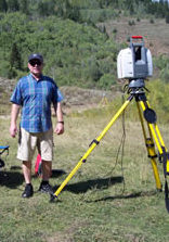
Kenny DeMeurichy, is a Terrestrial Laser Scanning (TLS) Analyst & Research Technician for the ET-AL at Utah State University. Kenny earned a degree in Geomatics Engineering from California State University, Fresno in 2004 and over ten years of professional surveying experience, including three years in terrestrial laser scanning. Kenny runs TLS (also known as ground-based LiDaR) and surveying field campaigns for the ET-AL. Kenny is also instrumental in providing training to USU students, workshop participants, and help supports the Columbia Habitat Monitoring Program.
​

projects

CHaMP Surveying Protocol 
CHaMP Surveying Instructor 
CHaMP Total Station Data Analysis Developer 
CHaMP Multiple Survey Technology Data Integration 
Bridge Creek IMW Surveying Coordinator 
Bridge Creek IMW GIS Data Analysis 
2014 Bridge Creek IMW Ice Breaker! 
GCD development team member 
ETAL and FHC Lab Support
Archaeology, Sand Cliffs Signature Documentation, TLS

scholarly contributions

  •  Jonathan M. Peart, Sara C. Shults, Kenneth P. Cannon, Kenny DeMeurichy,  Molly Beka Cannon. Using 3D Laser Scanning Technology to Document the Sand Cliff Signatures Site Historic Inscriptions, Iron County, Utah. Utah Archaeology, 2013.
  • Bangen S, Wheaton JM and DeMeurichy KD. 2011. Methodological Intercomparison of Topographic & Aerial Photographic Habitat Survey Techniques.  Ecogeomorphology and Topographic Analysis Lab, Utah State University, Prepared for Eco Logical Research and NOAA, Logan, Utah, 33 pp.
Picture
Picture
Picture
Picture
Picture
This work is licensed under a
​ 
Creative Commons Attribution 4.0 International License.
  • Home
    • Fluvial Habitats Center
    • Wheaton et al (Lab)
    • Bouwes ELR Lab
    • News & Annoucements
    • New FHC Publications
    • FHC Location
    • FHC Factsheets & Posters
    • Contact
  • People
    • People in the Lab... Coming & Going
    • Graduate Students >
      • Lauren Herbine
      • Karen Bartelt
    • Research Staff >
      • Research Scientists >
        • Joe Wheaton
        • Nicolaas Bouwes
        • Wally Macfarlane
        • Stephen Bennett
      • Technicians >
        • Cashe Rasmussen
        • Chalese Hafen
        • Dylan Baum >
          • Brian Ferrara
    • Where are they now? >
      • Former Graduate Students >
        • Sara Bangen
        • Reid Camp
        • Florence Consolati
        • Daniel Hamill
        • Konrad Hafen
        • James Hensleigh
        • Nate Hough-Snee
        • Alan Kasprak
        • Martha Jensen
        • Ryan Lokteff
        • Connor Penrod
        • Rebecca Rossi
        • Sonya Welsh
      • Research Scientists >
        • Sara Bangen
        • James Hensleigh
        • Natalie Kramer
        • Pete McHugh
        • Elijah Portugal
        • Carl Saunders
        • Eric Wall
        • Gary O'Brien
      • Post-Docs >
        • Nicole Czarnomski
      • Technicians >
        • Micael Albonico
        • Braden Anderson
        • Adan Banda
        • Jordan Burningham
        • Kenny Demeurichy
        • Taylor Dudunake
        • Martha Jensen
        • Joshua Gilbert
        • Jordan Gilbert
        • Thomas Hafen
        • Landon Haycock
        • Matt Meier
        • Chris Smith
        • Geoff Stevens
      • Visiting Scholars >
        • Ester Ramos
  • FHC Projects
    • Current Projects >
      • Beaver Dam Censusing
      • Birch Creek Restoration
      • Escalante Watershed
      • BRAT 2018-2019 >
        • BRAT-Yakama
        • BRAT-John Day
        • BRAT-NF Burnt River
        • BRAT-Idaho
        • BRAT-Utah
        • BRAT-TNC
        • BRAT-GYA
        • Survey123
      • ELR: Asotin LWD Restoration and IMW
      • Price River Channel Analysis
    • Past Projects >
      • BLM >
        • BLM: Historic Sand Cliff Signatures Public Archeology Program
      • DOE: ICRRR >
        • DOE/ICRRR: Geomorphic Change Detection 4.0 Software Development
        • DOE/ICRRR: Geomorphic Change Detection in the Grand Canyon
        • DOE/ICRRR: MoRPHED PhD Studentship
      • Idaho Power Company >
        • Idaho Power: TLS Data Analysis
      • ELR >
        • ELR/BPA: CHaMP Grand Ronde Crew Variability Study
        • ELR/BPA: ISEMP Lemhi Topographic Survey Technique Intercomparison
        • ELR/BPA: ISEMP Bridge Creek Restoration & IMW
        • ELR/FHC/CTWS: Pine Creek Beaver Assisted Restoration Pilot Project
      • NSF >
        • NSF: zCloudTools: Making Point Clouds Useful for Earth Science
        • NSF: Sensitivity of Braided River Morphodynamics to Sediment Supply
      • UDWR >
        • UDWR: Beaver Restoration Assessment Tool (BRAT)
      • USFS >
        • USFS Classification of Columbia River Basin Riparian Vegetation
        • USFS: Comparison of Traditional Versus Ground-Based LiDaR Instream Haibtat Assessments
        • USFS: Temple Fork Watershed Fish & Beaver Ecology
      • USGS >
        • USGS: Big Rivers Monitoring Protocol Development
        • USGS: Dynamism and Persistence of Eddy Sand Bars in Grand Canyon
        • USGS: Riparian Vegetation Analysis
        • USGS: Support in Geographic and Geomorphic Information Analysis for the Colorado River in Grand Canyon
      • Other Sponsors (one off) >
        • BPA/SFR: Development of CHaMP Transformation Tool
        • GCT: Pilot Study: Testing the Beaver Restoration Assessment Tool (BRAT)
        • NOAA: Linking Fisheries,
        • NPS: Assessment of Indicator Sites
        • USU: Tracking Ecogeomorphic Dynamics in Beaver Dam Complexes
    • Study Site Pages >
      • Bridge Creek >
        • 2009 BDSS Structures
        • Bridge Creek April 2010 Drone Survey
      • River Feshie >
        • The River Feshie Catchment
        • Our Research
        • The Team
        • Posters, Papers, & More
        • Photo Gallery
  • Resources
    • ETAL Reading Group >
      • ETAL Reading Group Zotero Library
    • Courses & Workshops >
      • Courses & Workshops by Joe
    • Guides & Tips >
      • Figure Preparation Tutorials
      • Basic Computing Tips & Tricks >
        • Database & SQL Intro
        • Batch Unzip Script
        • Get a QR Code
        • GeoJSON
        • Markdown
        • Special Characters
        • USU VPN
      • GIS Help >
        • ArcGIS Education Edition
        • GIS Data Sources >
          • Connecting To The APFO Services
          • Connecting to the Utah AGRC Discover Imagery and Base Map Server
          • High Resolution Imagery for Utah State
      • How to Use Specific Software >
        • Adobe Illustrator >
          • Making GCD Figures for ET-AL Lab Using ArcGIS & Adobe Illustrator
        • ArcGIS Desktop - ArcMap >
          • GIS Tutorials
          • Creating DEMs, TINs and Terrains
          • How to divide polylines into a specified segment length
          • Simple Change Detection in ArcGIS
          • Working with Styles in ArcGIS
          • Fixing ActiveX Warning in ArcGIS 10.5
        • Box >
          • Migrating to Box Drive from Box Sync
        • EndNote >
          • EndNote X4 Basics
        • FastStone Capture
        • GitHub >
          • Make a GitHub Account
        • Picasa >
          • Geotagging images & making albums
        • Word >
          • Saving Word Documents as PDFs
          • Using Styles Effectively in Manuscripts & Reports
        • Zotero >
          • Adding from Browser
          • Cite-While-you-Write >
            • Citing in Google Docs
            • Cite in Word
      • Reccomended Software & Utilities
      • Surveying & Geomatics >
        • rtkGPS
      • Writing Resources >
        • Writing Literature Reviews (for Grads)
        • Writing Scientific Papers
        • Uploading Content to Research Gate
    • Lab Members Only >
      • Internal Resources >
        • When you First Start
        • Standard Software Suite
        • Lab Software License
        • Virtual Computing
        • Editing Workshop Flyers & Webpages
        • Travel
        • Vignettes
      • Internal FHC Announcements
      • FHC Workshops
      • ETAL Projects on Box
      • ETAL Non Project on Box
    • River Links >
      • Classification Schemes >
        • Eco-Geo-Hydro Mess
      • Free Literature
      • Rivers in the News
      • Videos & Galleries
  • Joe Wheaton