Wheaton Ecogeomorphology & Topographic Analysis Lab @ Fluvial Habitats Center
  • Home
    • Fluvial Habitats Center
    • Wheaton et al (Lab)
    • Bouwes ELR Lab
    • News & Annoucements
    • New FHC Publications
    • FHC Location
    • FHC Factsheets & Posters
    • Contact
  • People
    • People in the Lab... Coming & Going
    • Graduate Students >
      • Lauren Herbine
      • Karen Bartelt
    • Research Staff >
      • Research Scientists >
        • Joe Wheaton
        • Nicolaas Bouwes
        • Wally Macfarlane
        • Stephen Bennett
      • Technicians >
        • Cashe Rasmussen
        • Chalese Hafen
        • Dylan Baum >
          • Brian Ferrara
    • Where are they now? >
      • Former Graduate Students >
        • Sara Bangen
        • Reid Camp
        • Florence Consolati
        • Daniel Hamill
        • Konrad Hafen
        • James Hensleigh
        • Nate Hough-Snee
        • Alan Kasprak
        • Martha Jensen
        • Ryan Lokteff
        • Connor Penrod
        • Rebecca Rossi
        • Sonya Welsh
      • Research Scientists >
        • Sara Bangen
        • James Hensleigh
        • Natalie Kramer
        • Pete McHugh
        • Elijah Portugal
        • Carl Saunders
        • Eric Wall
        • Gary O'Brien
      • Post-Docs >
        • Nicole Czarnomski
      • Technicians >
        • Micael Albonico
        • Braden Anderson
        • Adan Banda
        • Jordan Burningham
        • Kenny Demeurichy
        • Taylor Dudunake
        • Martha Jensen
        • Joshua Gilbert
        • Jordan Gilbert
        • Thomas Hafen
        • Landon Haycock
        • Matt Meier
        • Chris Smith
        • Geoff Stevens
      • Visiting Scholars >
        • Ester Ramos
  • FHC Projects
    • Current Projects >
      • Beaver Dam Censusing
      • Birch Creek Restoration
      • Escalante Watershed
      • BRAT 2018-2019 >
        • BRAT-Yakama
        • BRAT-John Day
        • BRAT-NF Burnt River
        • BRAT-Idaho
        • BRAT-Utah
        • BRAT-TNC
        • BRAT-GYA
        • Survey123
      • ELR: Asotin LWD Restoration and IMW
      • Price River Channel Analysis
    • Past Projects >
      • BLM >
        • BLM: Historic Sand Cliff Signatures Public Archeology Program
      • DOE: ICRRR >
        • DOE/ICRRR: Geomorphic Change Detection 4.0 Software Development
        • DOE/ICRRR: Geomorphic Change Detection in the Grand Canyon
        • DOE/ICRRR: MoRPHED PhD Studentship
      • Idaho Power Company >
        • Idaho Power: TLS Data Analysis
      • ELR >
        • ELR/BPA: CHaMP Grand Ronde Crew Variability Study
        • ELR/BPA: ISEMP Lemhi Topographic Survey Technique Intercomparison
        • ELR/BPA: ISEMP Bridge Creek Restoration & IMW
        • ELR/FHC/CTWS: Pine Creek Beaver Assisted Restoration Pilot Project
      • NSF >
        • NSF: zCloudTools: Making Point Clouds Useful for Earth Science
        • NSF: Sensitivity of Braided River Morphodynamics to Sediment Supply
      • UDWR >
        • UDWR: Beaver Restoration Assessment Tool (BRAT)
      • USFS >
        • USFS Classification of Columbia River Basin Riparian Vegetation
        • USFS: Comparison of Traditional Versus Ground-Based LiDaR Instream Haibtat Assessments
        • USFS: Temple Fork Watershed Fish & Beaver Ecology
      • USGS >
        • USGS: Big Rivers Monitoring Protocol Development
        • USGS: Dynamism and Persistence of Eddy Sand Bars in Grand Canyon
        • USGS: Riparian Vegetation Analysis
        • USGS: Support in Geographic and Geomorphic Information Analysis for the Colorado River in Grand Canyon
      • Other Sponsors (one off) >
        • BPA/SFR: Development of CHaMP Transformation Tool
        • GCT: Pilot Study: Testing the Beaver Restoration Assessment Tool (BRAT)
        • NOAA: Linking Fisheries,
        • NPS: Assessment of Indicator Sites
        • USU: Tracking Ecogeomorphic Dynamics in Beaver Dam Complexes
    • Study Site Pages >
      • Bridge Creek >
        • 2009 BDSS Structures
        • Bridge Creek April 2010 Drone Survey
      • River Feshie >
        • The River Feshie Catchment
        • Our Research
        • The Team
        • Posters, Papers, & More
        • Photo Gallery
  • Resources
    • ETAL Reading Group >
      • ETAL Reading Group Zotero Library
    • Courses & Workshops >
      • Courses & Workshops by Joe
    • Guides & Tips >
      • Figure Preparation Tutorials
      • Basic Computing Tips & Tricks >
        • Database & SQL Intro
        • Batch Unzip Script
        • Get a QR Code
        • GeoJSON
        • Markdown
        • Special Characters
        • USU VPN
      • GIS Help >
        • ArcGIS Education Edition
        • GIS Data Sources >
          • Connecting To The APFO Services
          • Connecting to the Utah AGRC Discover Imagery and Base Map Server
          • High Resolution Imagery for Utah State
      • How to Use Specific Software >
        • Adobe Illustrator >
          • Making GCD Figures for ET-AL Lab Using ArcGIS & Adobe Illustrator
        • ArcGIS Desktop - ArcMap >
          • GIS Tutorials
          • Creating DEMs, TINs and Terrains
          • How to divide polylines into a specified segment length
          • Simple Change Detection in ArcGIS
          • Working with Styles in ArcGIS
          • Fixing ActiveX Warning in ArcGIS 10.5
        • Box >
          • Migrating to Box Drive from Box Sync
        • EndNote >
          • EndNote X4 Basics
        • FastStone Capture
        • GitHub >
          • Make a GitHub Account
        • Picasa >
          • Geotagging images & making albums
        • Word >
          • Saving Word Documents as PDFs
          • Using Styles Effectively in Manuscripts & Reports
        • Zotero >
          • Adding from Browser
          • Cite-While-you-Write >
            • Citing in Google Docs
            • Cite in Word
      • Reccomended Software & Utilities
      • Surveying & Geomatics >
        • rtkGPS
      • Writing Resources >
        • Writing Literature Reviews (for Grads)
        • Writing Scientific Papers
        • Uploading Content to Research Gate
    • Lab Members Only >
      • Internal Resources >
        • When you First Start
        • Standard Software Suite
        • Lab Software License
        • Virtual Computing
        • Editing Workshop Flyers & Webpages
        • Travel
        • Vignettes
      • Internal FHC Announcements
      • FHC Workshops
      • ETAL Projects on Box
      • ETAL Non Project on Box
    • River Links >
      • Classification Schemes >
        • Eco-Geo-Hydro Mess
      • Free Literature
      • Rivers in the News
      • Videos & Galleries
  • Joe Wheaton

UDWR: Beaver Restoration Assessment Tool (BRAT)

project overview

purpose of project

Extend the Beaver Restoration Assessment Tool (BRAT) a cost-effective, transferable  spatially-explicit assessment tool for estimating beaver capacity and stream and riparian restoration potential across the entire state of Utah.

abstract

Beaver (Castor canadensis) dam-building activities lead to a cascade of hydrologic, geomorphic and ecological effects that increase stream complexity, which benefits a wide-variety of aquatic and terrestrial species. Depending on biophysical and vegetation conditions present, beaver dam-building activities variously trap sediment; raise incised streambeds, often reconnecting them with their floodplains; subirrigate the valley downstream of a dam; create wetlands; slow runoff; mitigate impacts by floods; extend seasonal streamflow; increase stream complexity; extend riparian woody and other vegetation; and create or increase habitat for diverse and sometimes rare species, including amphibians, fish, small mammals, and birds. As a result, beaver are increasingly being used as a critical component of passive stream and riparian restoration strategies. Using beaver as part of a restoration design is appealing because it is much less expensive than conventional stream restoration. As long as beaver have access to sufficient water, food and construction materials they can construct dams over an incredibly diverse range of climatic and physiographic conditions spanning from desert streams to alpine meadows.  However, the capacity of the landscape to support such dam building activity can vary dramatically across these settings according to the flow regime and the availability of dam building materials.

In this pilot project, we developed a spatially-explicit model to assess the capacity of landscapes in and around streams and rivers to support dam building activity for beaver. Capacity was assessed in terms of readily available nation-wide GIS datasets to assess key habitat capacity indicators: water availability, relative abundance of preferred food/building materials and stream power at base flows versus regular floods (i.e. 2-year recurrence interval flows). Stream power was calculated using USGS regional regression equations and calibrated to determine where dams could be built based on base flow stream power and persist from year-to-year based on two-year recurrence interval stream power. Fuzzy inference systems were used to assess the relative importance of these inputs which allowed explicit incorporation of uncertainty resulting from categorical ambiguity of inputs into the capacity model. Factors that can potentially limit beaver from realizing the full capacity to support dams include: 1) ungulate grazing capacity 2) proximity to human conflicts (e.g., irrigation diversions, settlements) 3) conservation/management objectives (endangered fish habitat) and 4) projected benefits related to beaver re-introductions (e.g., repair incisions). Future work will combine these additional inputs into a more all-encompassing model, which we call the Beaver Restoration and Assessment Tool (BRAT). This pilot project represents the first phase of development of BRAT.

In the current project we build on a case study application and verification/validation data from the Escalante River watershed in southern Utah, a diverse watershed that contains riverscapes ranging from desert canyonlands and washes to wet alpine meadows. Model validation/calibration was conducted in both the Escalante and the Logan River watersheds in northern Utah, an area where beaver dam census data and correlated stream power and beaver dam establishment and persistence data exist. Results indicate that beaver capacity varies widely within both study areas, but follows predictable spatial patterns that correspond to distinct ecoregions and vegetation communities. We show how the capacity model is a tractable rapid assessment method and decision support tool for inventorying watersheds to assess beaver dam building capacity. Because the model used freely and readily available nation-wide GIS data as model inputs the model can be easily applied to other watersheds. If better quality, higher resolution inputs are used, more refined model predictions are possible. However, we illustrate how the capacity model can be used to help resource managers develop and implement restoration and conservation strategies employing beaver that will have the greatest potential to yield increases in biodiversity and ecosystem services. When this model is eventually combined in BRAT with other limiting factors and management realities, this could become part of a powerful suite of scenario building and planning tools. ​

methods

​The primary driver of the model is the availability of suitable vegetation to support beaver dam building activity. The figure below illustrates how LANDFIRE data is classified, clipped and used to assess the capacity of every 250 m stream segment in the perennial drainage network to support dam building activity. 
Picture
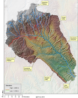
Figure 1. Study area map showing land status
Picture
 After vegetation is considered, we use that as an input into an overall capacity model, which also considers the likelihood that beaver can build a dam at baseflows (2), and the likelihood of that dam to withstand typical floods (3). ​
Picture
To verify model performance we can compare the model with dam surveys as shown below:
Picture

significance of project

  • This project will help watershed and resource managers better assess the capacity and recovery potential of the landscape to use beaver as a conservation, restoration and climate adaptation tool.  
  • The project will help scientists better forecast the influence beaver could have on our stream ecosystems should they achieve some proportion of their recovery potential.
Picture
Picture
Picture
Picture
Picture
This work is licensed under a
​ 
Creative Commons Attribution 4.0 International License.
  • Home
    • Fluvial Habitats Center
    • Wheaton et al (Lab)
    • Bouwes ELR Lab
    • News & Annoucements
    • New FHC Publications
    • FHC Location
    • FHC Factsheets & Posters
    • Contact
  • People
    • People in the Lab... Coming & Going
    • Graduate Students >
      • Lauren Herbine
      • Karen Bartelt
    • Research Staff >
      • Research Scientists >
        • Joe Wheaton
        • Nicolaas Bouwes
        • Wally Macfarlane
        • Stephen Bennett
      • Technicians >
        • Cashe Rasmussen
        • Chalese Hafen
        • Dylan Baum >
          • Brian Ferrara
    • Where are they now? >
      • Former Graduate Students >
        • Sara Bangen
        • Reid Camp
        • Florence Consolati
        • Daniel Hamill
        • Konrad Hafen
        • James Hensleigh
        • Nate Hough-Snee
        • Alan Kasprak
        • Martha Jensen
        • Ryan Lokteff
        • Connor Penrod
        • Rebecca Rossi
        • Sonya Welsh
      • Research Scientists >
        • Sara Bangen
        • James Hensleigh
        • Natalie Kramer
        • Pete McHugh
        • Elijah Portugal
        • Carl Saunders
        • Eric Wall
        • Gary O'Brien
      • Post-Docs >
        • Nicole Czarnomski
      • Technicians >
        • Micael Albonico
        • Braden Anderson
        • Adan Banda
        • Jordan Burningham
        • Kenny Demeurichy
        • Taylor Dudunake
        • Martha Jensen
        • Joshua Gilbert
        • Jordan Gilbert
        • Thomas Hafen
        • Landon Haycock
        • Matt Meier
        • Chris Smith
        • Geoff Stevens
      • Visiting Scholars >
        • Ester Ramos
  • FHC Projects
    • Current Projects >
      • Beaver Dam Censusing
      • Birch Creek Restoration
      • Escalante Watershed
      • BRAT 2018-2019 >
        • BRAT-Yakama
        • BRAT-John Day
        • BRAT-NF Burnt River
        • BRAT-Idaho
        • BRAT-Utah
        • BRAT-TNC
        • BRAT-GYA
        • Survey123
      • ELR: Asotin LWD Restoration and IMW
      • Price River Channel Analysis
    • Past Projects >
      • BLM >
        • BLM: Historic Sand Cliff Signatures Public Archeology Program
      • DOE: ICRRR >
        • DOE/ICRRR: Geomorphic Change Detection 4.0 Software Development
        • DOE/ICRRR: Geomorphic Change Detection in the Grand Canyon
        • DOE/ICRRR: MoRPHED PhD Studentship
      • Idaho Power Company >
        • Idaho Power: TLS Data Analysis
      • ELR >
        • ELR/BPA: CHaMP Grand Ronde Crew Variability Study
        • ELR/BPA: ISEMP Lemhi Topographic Survey Technique Intercomparison
        • ELR/BPA: ISEMP Bridge Creek Restoration & IMW
        • ELR/FHC/CTWS: Pine Creek Beaver Assisted Restoration Pilot Project
      • NSF >
        • NSF: zCloudTools: Making Point Clouds Useful for Earth Science
        • NSF: Sensitivity of Braided River Morphodynamics to Sediment Supply
      • UDWR >
        • UDWR: Beaver Restoration Assessment Tool (BRAT)
      • USFS >
        • USFS Classification of Columbia River Basin Riparian Vegetation
        • USFS: Comparison of Traditional Versus Ground-Based LiDaR Instream Haibtat Assessments
        • USFS: Temple Fork Watershed Fish & Beaver Ecology
      • USGS >
        • USGS: Big Rivers Monitoring Protocol Development
        • USGS: Dynamism and Persistence of Eddy Sand Bars in Grand Canyon
        • USGS: Riparian Vegetation Analysis
        • USGS: Support in Geographic and Geomorphic Information Analysis for the Colorado River in Grand Canyon
      • Other Sponsors (one off) >
        • BPA/SFR: Development of CHaMP Transformation Tool
        • GCT: Pilot Study: Testing the Beaver Restoration Assessment Tool (BRAT)
        • NOAA: Linking Fisheries,
        • NPS: Assessment of Indicator Sites
        • USU: Tracking Ecogeomorphic Dynamics in Beaver Dam Complexes
    • Study Site Pages >
      • Bridge Creek >
        • 2009 BDSS Structures
        • Bridge Creek April 2010 Drone Survey
      • River Feshie >
        • The River Feshie Catchment
        • Our Research
        • The Team
        • Posters, Papers, & More
        • Photo Gallery
  • Resources
    • ETAL Reading Group >
      • ETAL Reading Group Zotero Library
    • Courses & Workshops >
      • Courses & Workshops by Joe
    • Guides & Tips >
      • Figure Preparation Tutorials
      • Basic Computing Tips & Tricks >
        • Database & SQL Intro
        • Batch Unzip Script
        • Get a QR Code
        • GeoJSON
        • Markdown
        • Special Characters
        • USU VPN
      • GIS Help >
        • ArcGIS Education Edition
        • GIS Data Sources >
          • Connecting To The APFO Services
          • Connecting to the Utah AGRC Discover Imagery and Base Map Server
          • High Resolution Imagery for Utah State
      • How to Use Specific Software >
        • Adobe Illustrator >
          • Making GCD Figures for ET-AL Lab Using ArcGIS & Adobe Illustrator
        • ArcGIS Desktop - ArcMap >
          • GIS Tutorials
          • Creating DEMs, TINs and Terrains
          • How to divide polylines into a specified segment length
          • Simple Change Detection in ArcGIS
          • Working with Styles in ArcGIS
          • Fixing ActiveX Warning in ArcGIS 10.5
        • Box >
          • Migrating to Box Drive from Box Sync
        • EndNote >
          • EndNote X4 Basics
        • FastStone Capture
        • GitHub >
          • Make a GitHub Account
        • Picasa >
          • Geotagging images & making albums
        • Word >
          • Saving Word Documents as PDFs
          • Using Styles Effectively in Manuscripts & Reports
        • Zotero >
          • Adding from Browser
          • Cite-While-you-Write >
            • Citing in Google Docs
            • Cite in Word
      • Reccomended Software & Utilities
      • Surveying & Geomatics >
        • rtkGPS
      • Writing Resources >
        • Writing Literature Reviews (for Grads)
        • Writing Scientific Papers
        • Uploading Content to Research Gate
    • Lab Members Only >
      • Internal Resources >
        • When you First Start
        • Standard Software Suite
        • Lab Software License
        • Virtual Computing
        • Editing Workshop Flyers & Webpages
        • Travel
        • Vignettes
      • Internal FHC Announcements
      • FHC Workshops
      • ETAL Projects on Box
      • ETAL Non Project on Box
    • River Links >
      • Classification Schemes >
        • Eco-Geo-Hydro Mess
      • Free Literature
      • Rivers in the News
      • Videos & Galleries
  • Joe Wheaton